Logo QuickRoute

QuickRoute is fast team GPS routing for emergency responders.

  • Use devices you already own
  • No clunky MDC or paper maps
  • Nationwide maps are updated weekly
  • Live syncing and connections to your whole team and ECC
  • Custom routing rules for your vehicle based on manufacturer spec and jurisdiction policies

Features

Directions customized for 12 different emergency vehicle types

Specific modes of travel, real time updates, ECC connectivity, hands free.

Make your own mark on the map.

Tag road obstructions, hazards, and obstacles. Your tags make everyone's routes better immediately.

Real time map

All road obstructions and hazards tagged by users appear on everyone's map in real time. Get updated situational awareness on road objstructions, hazards, accidents, and other items posted by first responders

CAD/ECC connector lets dispatchers send routes directly to you

QuickRoute's enterprise connectors let dispatchers send destinations directly to users through mobile push notifications.

Private groups for enterprise share locations, alerts, hazards, and obstructions.

Get complete visibility into your team. Know where everyone is AND where they are going! Quickroute allows users to share as much or as little information as they like with settings that can be updated at any time. [feature coming soon]

Plan for future road outages

Planned construction, large events, or other road outages can be scheduled ahead of time for QuickRoute users to be routed around.

QuickRoute Enterprise

The ECC app, part of the Enterprise level subscription features an interactive map display with vehicle tracking, pushing routes to users for hands-free navigation, and pre-planning of road outages. Also use the QuickRoute ECC map screen as a low cost AVL system or a backup for when CAD goes down.

Use the GPS and connectivity already built-in to your user's smartphones. QuickRoute uses high level encryption to show dispatchers and managers maps of locations, road obstructions, significant events, and available responders.

QuickRoute ECC interface

How it works

When you use the app to navigate in either emergency, or non-emergency mode, it takes into account the physical size and weight of your vehicle along with handling characteristics and your local jurisdicitons guidelines for how emergency vehicles can and should be operated.

These are then used to feed you directions that are ideal for your vehicle. You won't be sent over bridges that can't hold the weight of a water tender, or have to do three U-turns in a big command bus. If emergency mode gets you to a medical patient faster by using restricted access lanes, medians, or shortcuts, QuickRoute will tell you.

You can also tag road hazards right in the app and keep track of changing situations like road construction, floods, and debris obstructions. The routing system updates in real time, letting you and all emergency vehicles in the area benefit from clear and faster routes, even if they are from a different jurisdiciton. Whether you are part of a small department or a major city department - QuickRoute can keep you in sync and aware of your surroundings with the best routing info available.

Scan the QR codes

Download for iOS

Download for Andriod

Watch this video from DHS's Operational Field Assessment of QuickRoute

Questions you might be asking

How is this different from the mapping app that comes on my phone?

Google Maps and Apple Maps are great for everyday driving. They have up to date information and fast updates. What makes QuickRoute better is that we tailor the driving directions that are delivered to you based on your vehicle characteristics and your ability to use alternative procedures during an emergency.

What data are you using to make the routes unique?

A global database of road and infrastructure that is updated daily

Road and bridge weight limits and tunnel and bridge clearance from the US Department of Transportation

Manufacturer specs for common vehicle types: Ladder, Water Tender, Engine, Patrol Car, Ambulance, Crash Truck, SWAT Truck, K9 Unit, Command Bus, Utility Vehicle, Chief's Car

You can also load your own specs for a custom vehicle.

Can I get this myself or does my department need to buy it?

You can get the app for free from the App Stores. The free version only has generic routing, and no tagging of hazards, so what you really want is the upgrade to QuickRoute Pro. With that you'll have all the first responder routing rules, multiple vehicle profiles, and will benefit from emergency services tagging of obstacles and hazards in the roadway. But you won't be able to add your own tags for hazards. To do that we need to verify you're with a public safety organization who lets you into their private group. There's no extra cost for that for users, but the organization will need to have an enterprise and ECC license.

How much does it cost?

QuickRoute Pro is $10 per month per user when purchased by an individual. Organizations can purchase an enterprise account with discounted prices based on the number of mobile, ECC and admin users. Enterprise accounts get a private group to add QuickRoute users into. Being in the group means that ECC dispatchers can forward destinations for calls directly into QuickRoute without you having to type anything in. They also get a map view of where all of the users in their group are when they are on duty. Enterprise users can also plan ahead for outages - large sporting events, road blocks, planned construction - all of these can be added in advance so users can get routed aroud. Even Google Maps doesn't know to route around construction before it happens. Enterprise

More questions?

Get in touch

Story behind the app

The US Department of Homeland Security Science and Technology Directorate has a First Responder Group that researches all types of technological innovations that can help first responders. Fire Departments, Rescue Squads, Police Departments, and Disaster Preparedness.

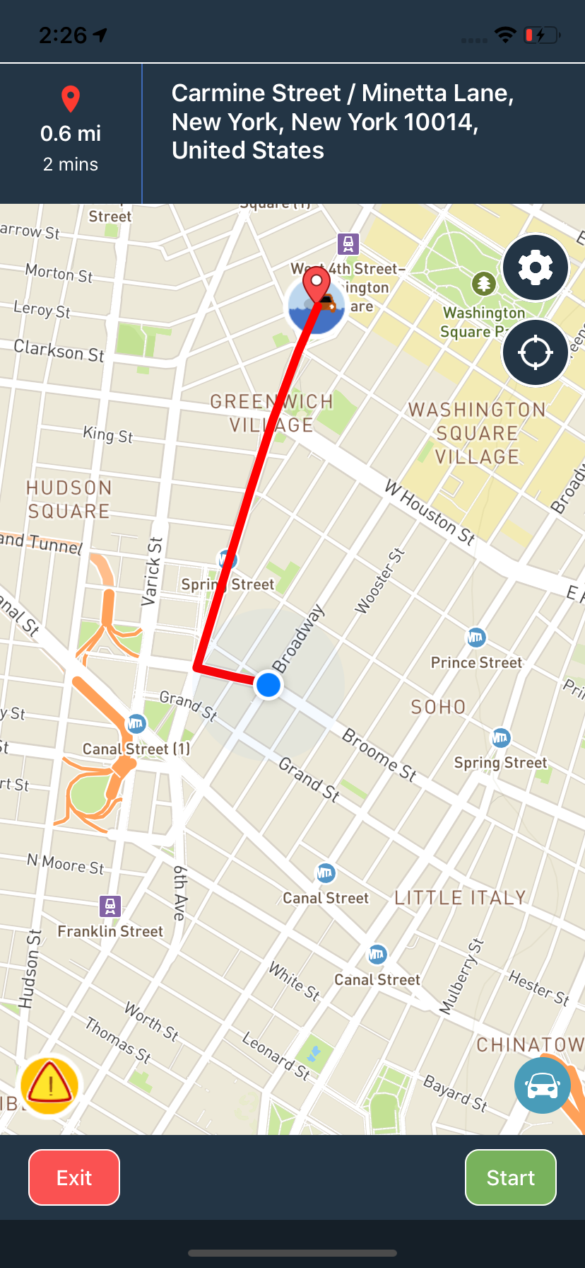
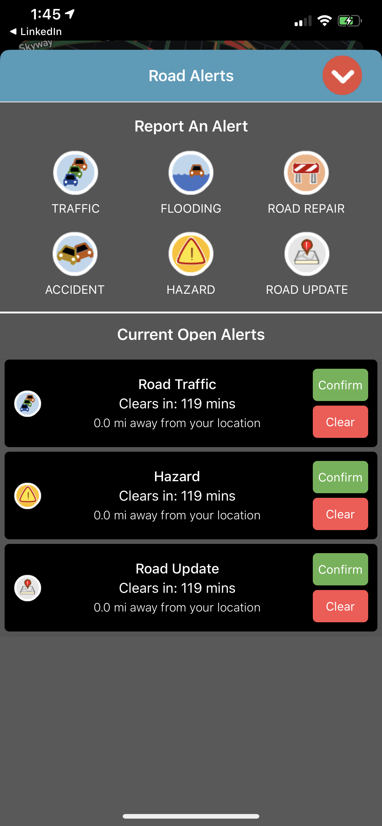
One of the capability gaps they identified was that when responders drive to a fire or medical emergency, they often have unneccesary delays because of bad directions, or running into travel restrictions - traffic, weather, constructions, etc. They thought it would be a great improvement if they had a system where they could tag these obstructions so that others who are trying to respond could be routed around them and save valuable time. Our team came up with a solution idea using mobile phones and tablets, connected through an online system that could handle routing especially for emergency vehicles.

QuickRoute is a creation of Azimuth1, a tech development company based in Virginia, with funding by the US Dept of Homeland Security. We built QuickRoute for our friends in public safety. Check it out at the app stores and read more about the advanced features that tie in your mobile device with dispatchers and other emergency vehicles in the area.

Pricing

QuickRoute Mobile

Free

  • 1 mobile user
  • civilian car and truck routes
  • 12 preset emergency vehicles
  • custom vehicles
  • ECC connectivity
  • email support
  • 24/7 phone support
Download

QuickRoute Mobile Pro

$10
per month

  • 1 mobile user
  • civilian car and truck routes
  • 12 preset emergency vehicles
  • 3 custom vehicles
  • ECC connectivity
  • email support
  • 24/7 phone support

QuickRoute Enterprise

$900
per month

  • ecc cloud application
  • discounted mobile user rates
  • 12 preset emergency vehicles
  • unlimited custom vehicles
  • CAD connectors
  • email support
  • 24/7 phone support
Request a Quote

Contact Us

We’d love to hear from you. Please reach out with any questions and comments or to request a quote for QuickRoute Enterprise.